Monroe County Downloadable GIS files
- LT/ED Matrix
- Codes for Matrix
- LT/ED Boundaries Shapefile
- State Senate Boundaries Shapefile
- State Assembly Boundaries Shapefile
- County Legislature Boundaries Shapefile
- Rochester City Council Boundaries Shapefile
- Greece Ward Boundaries Shapefile
- Village Boundaries Shapefile - 2023
 Monroe County Voting District Maps
The Board of Elections is now able to provide voters and the community with high-quality, full-color maps. All district maps are available for purchase at the Board of Elections office, however, some are also available for viewing online (see below).
Visit the New York State Board of Elections for maps encompassing state and/or federal jurisdictions.
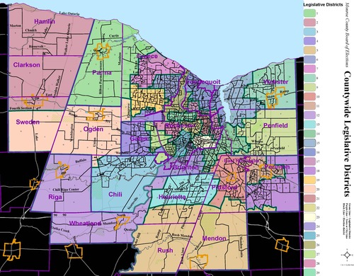
- County Wide
- City of Rochester County LDs
- City of Rochester County LDs w/o streets
- City of Rochester County LDs w/o EDs & streets
- Rochester City Council
- Rochester City Council - East
- Rochester City Council - Northeast
- Rochester City Council - Northwest
- Rochester City Council - South
- Brighton
- Chili
- Clarkson
- East Rochester
- Gates
- Greece
- Greece - Wards
- Hamlin
- Henrietta
- Irondequoit
- Mendon
- Ogden
- Parma
- Penfield
- Perinton
- Pittsford
- Riga
- Rush
- Sweden
- Webster
- Wheatland
- 1st Legislative District
- 2nd Legislative District
- 3rd Legislative District
- 4th Legislative District
- 5th Legislative District
- 6th Legislative District
- 7th Legislative District
- 8th Legislative District
- 9th Legislative District
- 10th Legislative District
- 11th Legislative District
- 12th Legislative District
- 13th Legislative District
- 14th Legislative District
- 15th Legislative District
- 16th Legislative District
- 17th Legislative District
- 18th Legislative District
- 19th Legislative District
- 20th Legislative District
- 21st Legislative District
- 22nd Legislative District
- 23rd Legislative District
- 24th Legislative District
- 25th Legislative District
- 26th Legislative District
- 27th Legislative District
- 28th Legislative District
- 29th Legislative District


